
Drone Mapping of Evidence: Revolutionizing Crime Scene Investigations
By Sarim Suleman on April 27, 2026, ref:
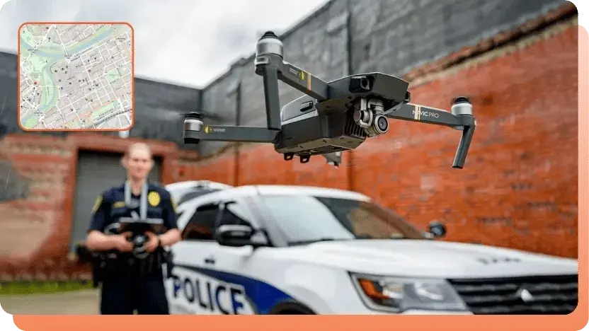
The growing use of drones in policing demands efficient mapping of footage. Discover how geospatial technology enhances evidence collection and transforms crime investigations. 
Think about the frustration of spending hours meticulously mapping a crime scene by hand, inserting pins on a large paper map, and connecting them with threads to recreate the scene. For investigators, this time-consuming process was once the only way to map crime scenes. But in a world where every second counts, can law enforcement agencies afford such inefficiency?
Take the city of Bend, Oregon, where the use of drones in police investigations has doubled since 2022. It's an approach that has rendered traditional methods impractical. And that’s precisely where drone mapping of evidence proves to be a game-changing technology revolutionizing how law enforcement agencies document crime scenes.
With drone mapping of evidence, investigators can now quickly and accurately map a scene captured by a drone, eliminating manual labor and guesswork. This advanced technology enables police departments to efficiently manage and analyze the growing loads of aerial evidence footage, significantly improving response times and accuracy.
Drone evidence mapping transforms raw data into actionable insights, reducing the workload of law enforcement agencies and eliminating the errors associated with manual data collection and analysis. By using geospatial technology through KLV metadata, investigators can turn raw aerial footage into precise crime scene reconstructions.
In this blog, we’ll explore how drone mapping leverages geospatial technology to transform crime scene investigations. We’ll also explore the role of drone mapping in modern law enforcement, its key benefits, and use cases that leverage digital mapping of aerial footage to streamline the investigative process.
Understanding Geospatial Technology and KLV Metadata in Drone Mapping of Evidence
At the core of drone mapping is the integration of geospatial technology that uses KLV (Key-Length-Value) metadata. This enables law enforcement agencies to transform raw aerial footage into precise, actionable crime scene reconstructions with unmatched accuracy and efficiency.
Geospatial technology encompasses the tools used to collect, analyze, and visualize geographic data. At the heart of this process is KLV (Key-Length-Value) metadata, a standard format for embedding crucial information, such as time, GPS coordinates, and sensor location, into drone video footage. This metadata ensures that every frame of the video is linked to precise geographic details, allowing for the seamless capture of a crime scene’s data, which can then be processed into detailed digital maps, allowing drone mapping of evidence.
This combination of geospatial technology and KLV metadata enables law enforcement to map crime scenes with unprecedented accuracy and precision. By linking each video frame to its exact location and time, investigators gain a comprehensive view of the crime scene, as seen through aerial footage. This significantly reduces the manual effort required for traditional evidence mapping, replacing pins and threads with precise and efficient documentation. It ensures accuracy, minimizes errors, and accelerates investigations.
Practical Applications of Drone Mapping in Law Enforcement
With the development of technology, the nature of crime has also evolved. Investigating every reported crime has become the need of the hour. With drone footage contributing significantly to evidence collection in today’s era, its mapping has been crucial.
Evidence mapping from drone footage has proven particularly effective in scenarios involving large-scale crime scenes, such as mass shootings or natural disasters, where capturing and analyzing extensive areas quickly is crucial. Let us explore some cases where the mapping of drone evidence is a go-to tool for law enforcement agencies.
Search And Rescue Operations
Drones equipped with geospatial technology are invaluable in search and rescue operations, particularly in difficult-to-navigate terrains such as rocky or hilly areas, cliffs, rivers, larger bodies of water, or disaster zones. In these situations, drone mapping of evidence enables the rapid scanning of vast regions, reducing the time it would take ground teams to cover the same terrain.
Drones provide accurate geolocation data, enabling geo-mapping of aerial footage with precise GPS coordinates. This allows rescue teams to quickly analyze the data to identify potential signs or tracks of missing persons. It also allows teams to act swiftly and reach remote or inaccessible locations with greater efficiency, ultimately improving the chances of a successful recovery through better coordination and faster decision-making.
Crime Scene Analysis
Geo-mapping of drone footage offers law enforcement a powerful tool for enhancing crime scene analysis. By providing a detailed view of a crime scene, drones enable investigators to visualize relationships between pieces of evidence more effectively, leading to quicker and more accurate conclusions.
Mapping evidence geographically enables law enforcement to detect patterns of crimes and analyze trends. This visual representation of data makes it easier to predict crime spikes and respond more efficiently. For example, by identifying criminal hotspots for burglaries or vehicle thefts, police can strategically allocate resources, optimize patrol routes, and increase their presence where it is most needed.
Additionally, drone mapping of evidence adds to criminal profiling by tracking the movements and behaviors of offenders across multiple crime scenes. This makes it easier to anticipate future incidents and helps build more robust cases against suspects.
Traffic and Accident Analysis
In traffic accidents, drones equipped with geospatial technology can quickly survey the scene from above, capturing detailed aerial footage that can be mapped and analyzed for further investigation. This allows investigators to recreate the accident scene, measure distances between vehicles, and assess road conditions, all in a fraction of the time it would take to do so manually.
Drone mapping of evidence also aids in analyzing accident hotspots, helping law enforcement improve road safety measures and adjust traffic flows. Law enforcement can develop strategic interventions to prevent future accidents and law-breaking by pinpointing areas with recurring incidents.
Crowd Safety
Drones are crucial for analyzing incidents in large crowds at events, protests, or public gatherings. Geospatial technology enables drones to map crowds during incidents, providing law enforcement with a comprehensive view of movement, patterns, and potential causes of incidents.
This visual data, combined with mapping on digital maps, enables authorities to identify high-risk areas for stampedes, overcrowding, or security breaches. By analyzing these mapped crowd behaviors, law enforcement can deploy resources more effectively to prevent dangerous situations and ensure public safety.
Tactical Exercises
Law enforcement and military units can use geospatial mapping to analyze tactical training and exercises. Drones capture data used to plan and execute strategies with heightened accuracy. Using drone mapping of evidence, tactical teams can review and improve their performance after training sessions, ensuring better coordination and preparation for real-world operations.
Also, by reviewing past incidents captured through drone footage, agencies can learn from previous cases and improve their techniques. This technology enhances situational awareness and decision-making, leading to more effective responses in critical scenarios.
Geospatial Mapping and Digital Evidence Management Systems
Drone mapping of evidence using geospatial technology is transforming the landscape of crime scene investigation and analysis. Modern Digital Evidence Management Systems (DEMS) enable law enforcement agencies to utilize these technologies to efficiently capture and reconstruct aerial footage of crime scenes with great detail. Features like heat mapping and 3D crime scene reconstructions may also be developed in the future to help investigators visualize areas with the most activity or focus, providing deeper insights and a comprehensive view of the crime.
As technology advances, Digital Evidence Management Systems (DEMS) are rolling out features that allow for seamless ingestion and analysis of drone footage, making it easier for law enforcement to analyze, store, and share geospatially mapped evidence. With AI integration on the horizon, these systems will soon automate real-time analysis, identifying key evidence and suspect movements with greater speed and accuracy. Powered by machine learning, this predictive crime mapping can also help law enforcement anticipate future crime hotspots, allowing for proactive measures in crime prevention.
Other Features that Come in Handy: Dealing with Drone Footage
While drone mapping of evidence and geospatial technology significantly enhance crime scene analysis, integrating other advanced features further improves investigation accuracy and efficiency. Modern digital evidence management systems now enable the application of enhanced features to drone footage, thereby improving crime analysis and data sharing.
Frame-by-Frame Evidence Analysis
Frame-by-frame playback enables investigators to advance drone footage one frame at a time. This allows them to get a closer look at critical moments or objects within a crime scene. By analyzing each frame separately, investigators can identify crucial details that may not be immediately visible in real-time playback. This meticulous approach helps to ensure no vital evidence is overlooked, especially in dynamic crime scenes where timing and positioning are key factors.
Annotations
Annotations enable investigators to interact directly with video footage, allowing them to add notes, comments, or tags to specific frames. Whether it's a critical object in the background of a crime scene or a suspicious action within a crowd, annotations make it easier to highlight these elements for further analysis. By marking specific frames, investigators can streamline the evidence review process, making the overall analysis more efficient and structured.
When applied to drone footage, especially in the context of crime scene investigations, annotations can greatly enhance the value of the captured evidence. Drone footage often spans large areas and captures numerous details, making it difficult to focus on key pieces of evidence without a clear structure. Through frame-by-frame navigation and annotations, investigators can pinpoint exact moments or objects crucial for the case. This approach ensures that critical evidence is documented, shared, and easily referenced during the investigation, improving collaboration and the accuracy of crime scene analysis.
Redaction
In certain situations, such as when drones are used to capture aerial footage of large crowds during protests or public demonstrations, privacy concerns may arise. This is where redaction is essential to protect personal identities and ensure compliance with privacy laws, such as GDPR.
Redaction allows investigators to blur or black out sensitive information captured in drone footage, such as faces, vehicle license plates, or other personally identifiable information (PII). Redaction ensures that evidence can be shared securely with relevant parties, such as legal teams or external agencies, without violating privacy regulations.
Key Takeaways
-
Drone Mapping Enhances Crime Scene Analysis
Drone mapping enables law enforcement to capture aerial footage of crime scenes and convert it into detailed digital maps, facilitating faster and more precise investigations. -
Geospatial Technology and KLV Metadata Power the Process
By embedding GPS coordinates, timestamps, and sensor data into video frames, KLV metadata ensures that every piece of footage is accurately mapped for evidence tracking. -
Rapid Response in Search and Rescue Operations
Drones equipped with geolocation tools significantly reduce response times under challenging terrains by scanning vast areas and delivering real-time coordinates to rescue teams. -
Improved Crime Pattern Analysis
Digital evidence mapping helps visualize the relationship between evidence points, identify crime trends, and support predictive policing efforts. -
Efficient Traffic and Accident Reconstruction
Drone footage can be geo-mapped to quickly reconstruct accident scenes, aiding in the analysis of crash dynamics, distance measurements, and road conditions. -
Enhanced Crowd Monitoring and Public Safety
Drones provide comprehensive situational awareness during large gatherings, enabling the identification of high-risk zones and preventing overcrowding or stampedes. -
Training and Tactical Planning Made Smarter
Tactical teams can use drone mapping during exercises to review performance, analyze past incidents, and refine real-world response strategies. -
Integration with Digital Evidence Management Systems (DEMS)
Modern DEMS ingest drone footage, enabling law enforcement to store, analyze, and share mapped evidence with enhanced features, including 3D visualization, AI tagging, and more. -
Advanced Features Maximize Investigative Efficiency
Frame-by-frame analysis, annotations, and AI-powered redaction enhance the usability of drone footage, protect privacy, and ensure compliance with laws such as GDPR and CJIS. -
VIDIZMO Leads Innovation in Drone Evidence Management
VIDIZMO DEMS supports seamless ingestion, annotation, redaction, and geospatial mapping of drone footage, empowering public safety teams to work faster and smarter.
Redefining Modern Policing: Drones as Strategic Assets
Drones equipped with geospatial mapping technology are revolutionizing crime scene investigations. They enable law enforcement agencies to capture aerial evidence, analyze it in detail, and ultimately enhance their investigative capabilities.
Drones have played a crucial role in solving complex cases by providing aerial imagery that maps crime scenes, tracks suspect movements, and gathers evidence from inaccessible areas. This technology was instrumental in resolving a high-profile double murder case in Delhi by helping investigators map out key details from the crime scene.
Similarly, the St. Johns County Sheriff’s Office has leveraged drones for geospatial mapping in its operations. By capturing comprehensive aerial data, law enforcement in the area can efficiently analyze crime scenes, locate missing persons, and assess hazardous conditions, adding significant value to their investigative processes.
These examples highlight how drone mapping of evidence transforms modern law enforcement by providing detailed insights. The ability to analyze large areas quickly and precisely improves the efficiency and effectiveness of crime scene investigations, making drones a valuable asset for law enforcement agencies worldwide.
As technology continues to evolve, Digital Evidence Management Systems (DEMS) are poised to further enhance these capabilities by integrating artificial intelligence and machine learning, providing even faster and more accurate analysis of drone footage. This will ultimately shape the future of drone mapping for evidence collection, crime prevention, and investigation.
People Also Ask
What is drone mapping of evidence in crime scene investigations?
It’s the process of using drones to capture aerial footage of crime scenes, which is then converted into digital maps to support faster and more accurate investigations.
How does geospatial technology enhance drone mapping?
Geospatial technology, utilizing KLV metadata, links footage to GPS data and timestamps, enabling investigators to map scenes with high precision.
What are the benefits of drone mapping of evidence for law enforcement?
It speeds up crime scene documentation, improves accuracy, and helps law enforcement analyze evidence from large or inaccessible areas.
Why is KLV metadata important in crime scene investigations?
KLV metadata adds vital details, such as time and location, to each video frame, ensuring precise and reliable crime scene reconstructions.
How does drone mapping support crime trend analysis?
Mapping where crimes occur helps identify hotspots and patterns, enabling police to plan more effective responses and deploy resources more wisely.
Can drones be used in traffic accident investigations?
Yes, drones quickly capture aerial views of accidents, helping reconstruct scenes and assess conditions for faster reporting and analysis.
What role do drones play in search and rescue missions?
Drones scan large, rugged terrains and provide real-time GPS data, making it easier and quicker to locate missing persons.
Are drones useful for crowd safety monitoring?
They map and monitor large gatherings, helping identify overcrowding or threats, improving public safety and response planning.
How does drone mapping assist tactical operations?
Drones provide real-time visuals for planning and reviewing tactical exercises, enhancing team coordination and decision-making.
What’s the future of drone mapping in evidence management?
AI-powered systems will soon automate footage analysis, detect key evidence, and support predictive crime mapping for proactive policing.
About the Author

Sarim Suleman
Sarim Suleman is a Product Marketing Executive at VIDIZMO with deep expertise in enterprise video platforms and digital evidence management. He focuses on helping government agencies and large-scale organizations understand how modern video and AI technology can transform their evidence workflows and operational efficiency.
Jump to
You May Also Like
These Related Stories

A Complete Guide to Integrating Intelligence into Your Evidence Management System

The Growing Role of Digital Evidence in Public Defense


No Comments Yet
Let us know what you think